Developed an application for smartphones to guide users to their destinations in underground malls with complex structures by acquiring GPS information.
Background & Purpose
The internal structure of an underground shopping center had become increasingly complex as a result of repeated expansion and renovation over the years by multiple railroad companies and commercial facilities.
As a result, although partial maps were posted, it was difficult to express the entire map on a flat surface, and users often became lost because they could not easily grasp their current location and destination.
To solve this problem, we developed an application for smart phones that calculates and displays on a map the shortest route based on information on the complex, three-dimensional structure of the underground shopping center and the current location of people walking through the underground shopping center. To solve this problem, we were assigned to develop an application for smartphones that calculates the shortest route and displays it on a map based on information about the complex three-dimensional structure of the underground shopping mall.
Brand Experience
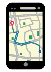
Within the application developed by our company, we have realized a function to search for a destination and acquire GPS information of the current location.
This function allows users to confirm how to walk from their current location to their destination.
By acquiring map information in conjunction with a map information provision API service, even pathways and obstacles inside underground malls are accurately displayed, allowing users to correctly grasp the route to their destinations and reach them without getting lost.
Moreover, map information is stored on the server side, rather than in the application, so there is no need to update the application when facility or tenant information is updated.