Dainippon Diamond Consultants, Inc. (DNE) is a general construction consultant that plays a wide range of roles from planning to design and maintenance for the purpose of improving "social capital" such as bridges, roads, and rivers.
As part of DNE's "Proof of Concept (PoC) of Disaster Prevention and Mitigation Risk System," AsiaQuest is providing comprehensive system development support for a 3D disaster simulation system that utilizes Web3D* technology, from technical research to infrastructure construction and front-end development. We provide comprehensive system development support ranging from technical research to infrastructure construction and front-end development for 3D disaster simulation systems utilizing Web3D* technology.
*What is Web3D?
Web3D is a generic term for technologies and standards for displaying and manipulating 3D (three-dimensional) graphics on the Web. This technology enables the deployment of interactive 3D visual content on the Internet and is used in various fields such as games, virtual reality (VR), augmented reality (AR), etc. Web3D technology is intended to allow users to experience 3D content using only a standard web browser without installing any additional software. Web3D technology aims to enable users to experience 3D content using only a standard web browser without the need to install additional software.
Background & Purpose
Importance of road maintenance incorporating disaster
risk and development of a platform to achieve this
In recent years, disaster prevention measures for road facilities must be strengthened to prepare for increasingly severe weather damage and imminent large earthquakes. In addition to "point maintenance," in which facilities are planned individually or by facility, it is also important to "line and plane maintenance" to reduce the risk of road network fragmentation caused by damage to road facilities and to ensure the effective functioning of the road network in the event of a disaster. The "line and plane development" perspective is also considered important to reduce the risk of road network fragmentation that may occur in the event of a disaster and to make the road network function effectively in the event of a disaster. In order to realize disaster-resilient urban development, it is important to ensure that the road network connecting the region functions effectively even in the event of a disaster.
Against this backdrop, DNE is promoting the development of quantitative evaluation technologies and advanced disaster prevention simulations using various digital data.
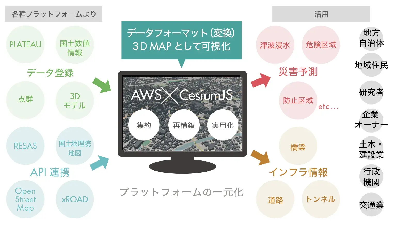
In this development, DNE is testing the feasibility of a system that consolidates multiple data scattered across various platforms, including disaster information, hazard maps, 3D maps, and facility specification data, into a single platform, predicts risks in the event of a disaster, and notifies residents of the extent of damage.
Role
System development using agile development methods.
Steady implementation with weekly sprint reviews.
AsiaQuest employs agile development to assist in the development of our systems.
In this process, a scrum master and programmers conduct technical research, infrastructure construction, and front-end development through weekly sprint reviews with the client. We also utilize a chat tool (Slack) for detailed checks and reports, and work closely with the client to ensure that development proceeds efficiently.
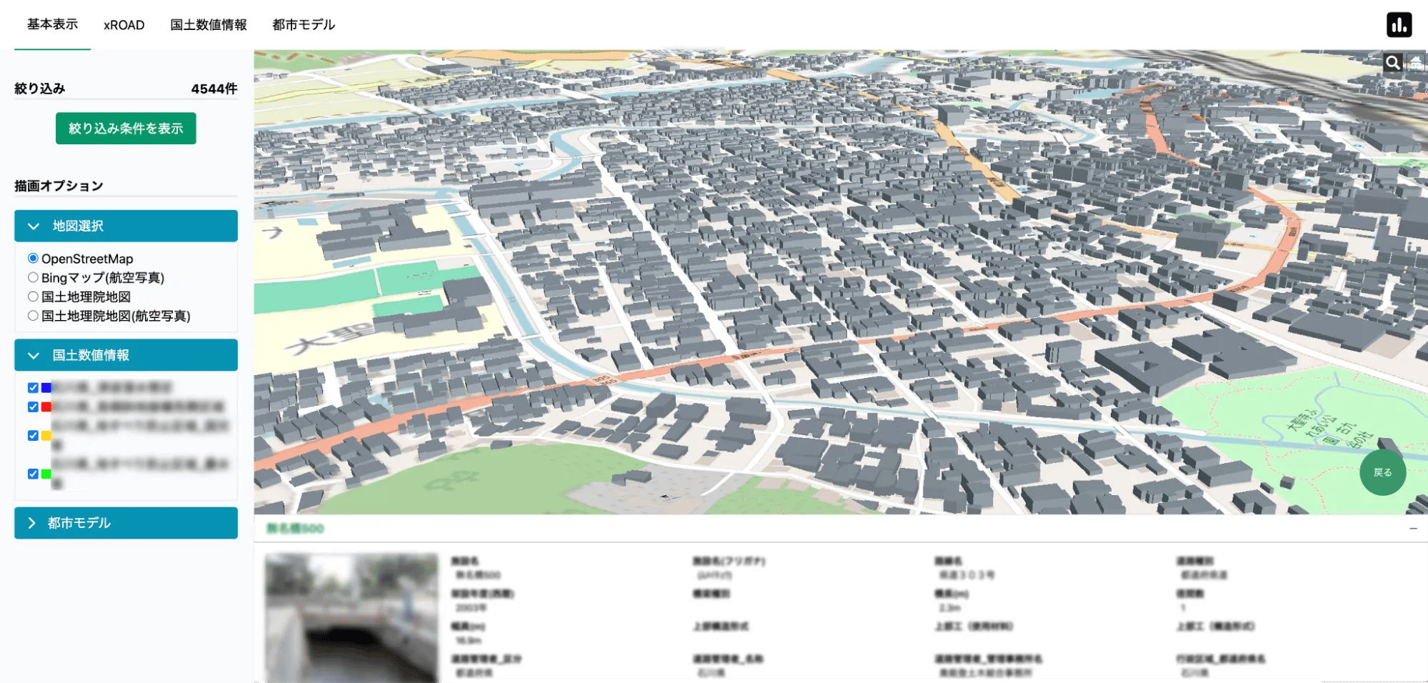
A single disaster forecasting platform that aggregates data from "PLATEAU," "xROAD," "National Land Numerical Information," and other sources
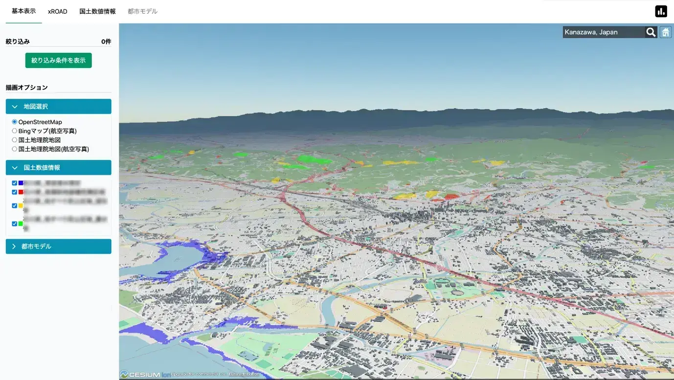
◼️ 3D urban model and data platform:
The 3D map was created by combining "PLATEAU" and "xROAD" provided by the Ministry of Land, Infrastructure, Transport and Tourism.
What is PLATEAU?
PLATEAU is a 3D open data model of cities throughout Japan, mainly in CityGML format. In addition, the data is converted to various data formats and widely distributed.
What is *xROAD?
xROAD is a data platform that links various data based on digital road maps and other data provided by the Road Bureau of the Ministry of Land, Infrastructure, Transport and Tourism. As part of this platform, the "Nationwide Road Facility Inspection Database" has been established, and basic data (specifications, inspection results, etc.) on bridges, tunnels, etc. are available to the public for a fee.
◾️ Data Visualization
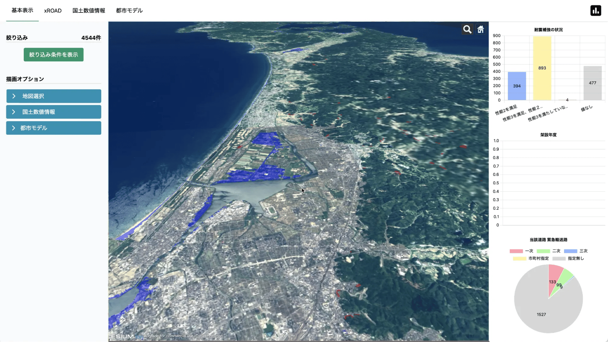
Visualize and display hazard maps "National Land Information Data" and other data on the created 3D map to predict disasters such as flooding.
*National Land Information Data This is public information prepared by the Ministry of Land, Infrastructure, Transport and Tourism to support the formulation and implementation of national land planning. It contains a variety of data related to national land, including administrative divisions, railroad networks, road networks, river systems, official land prices, land use mesh data, and public facilities.
◾️ Key Technologies
CesiumJS
What is CesiumJS? JavaScript library on an open source platform that enables visualization, analysis, and sharing of web-based geospatial data. It can display and analyze global 3D maps and supports real-time data rendering.
◾️ data compatibility and file conversion (format conversion)
Numerical information displayed on a 3D map contains a variety of extensions and languages. We continuously perform format conversions and validations to ensure compatibility.
◾️ Data Registration
Multiple data formats are supported, and uploaded data files are automatically converted to the format and drawn on the map.
◼️API support
Supports rendering of data acquired through API.
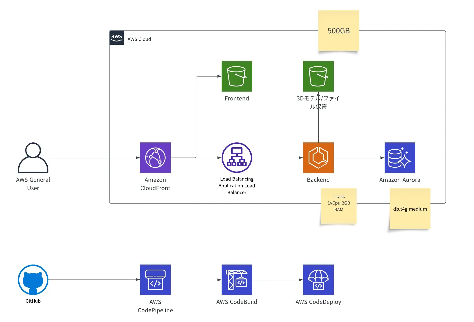
Building a Web3D System with "AWS" x "CesiumJS
This system aggregates publicly available 3D models (CityGML, 3DTiles, FBX, OBJ) and external data on multiple platforms into a single platform to render high-definition disaster forecast 3D maps.
AWS is used as the infrastructure for this process. Registered data files are formatted and converted on the back-end and stored in Amazon Simple Storage Service (Amazon S3), and rendered using Amazon Aurora database and Amazon CloudFront high-speed transfer. By using a load balancer, stable data processing is possible.
On the development side, we utilize AWS CodePipeline, AWS CodeBuild, and AWS CodeDeploy to provide an environment for direct deployment of development work on GitHub. This allows for efficient development.
Brand Experience
Wide range of data registration and smooth 3D simulation renderingWide range of data registration and smooth 3D simulation rendering
Disaster simulation can now be performed by integrating and displaying various types of data through 3D visualization of actual terrain data.
Function Overview
- 3D Model Registration Function
- Users can register 3D model data using a form to draw bridges, buildings, etc. in 3D on a map. This technology allows users to perform simulations using the digital twin.
- Data Registration Function
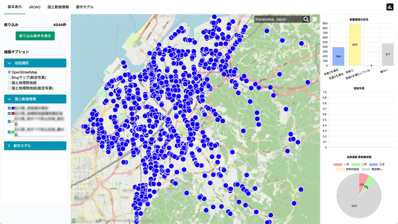
- By registering data files, users can display infrastructure information such as roads, bridges, and tunnels on a 3D map. By clicking on each spot, users can view more detailed information.
- Disaster Simulation Function
- This function simulates disasters such as floods, tsunamis, steep slopes, landslides, inundation, and fault lines in 3D and visualizes them on a 3D map.
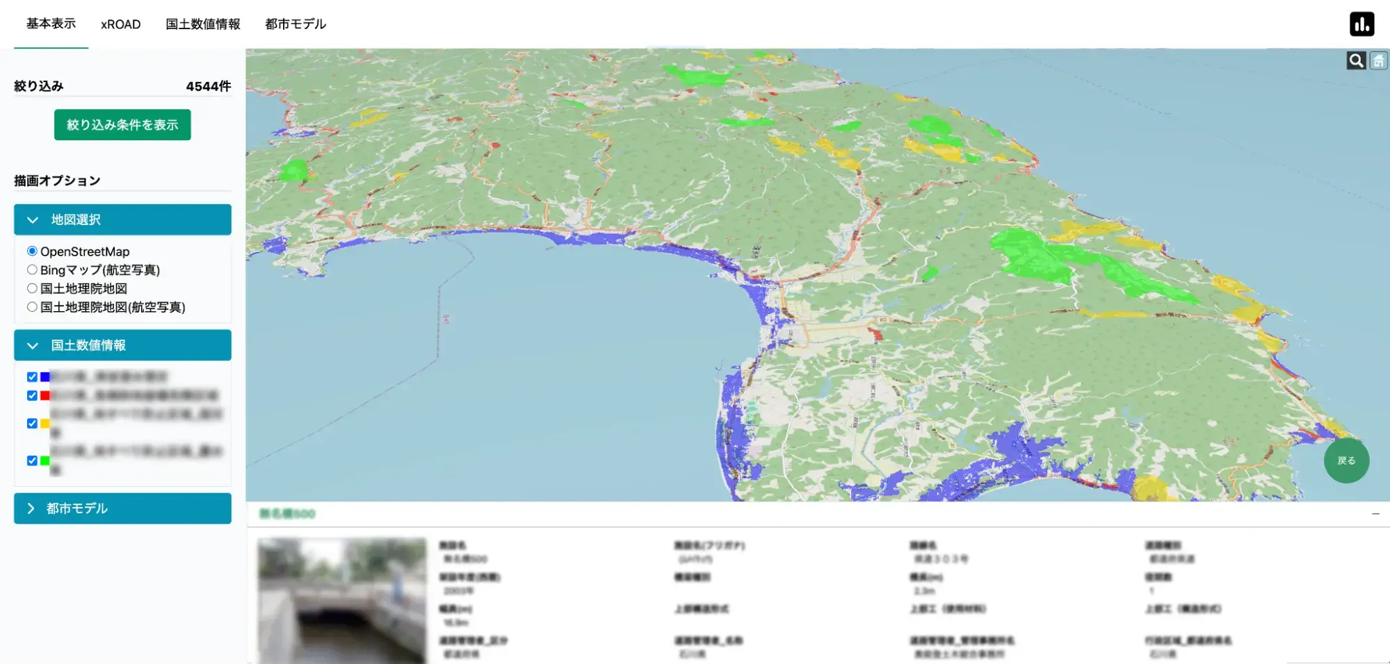
Blue: Tsukuba Submerged Area
Red: Rapidly Sloping Ground Failure Dangerous Areas
Yellow: Landslide Prevention Areas (Ministry of Transportation and Communications)
Green: Landslide prevention areas (Ministry of Agriculture and Water)
Outlook for the future
More visualized dashboards and search functions
We plan to add the following features in the future
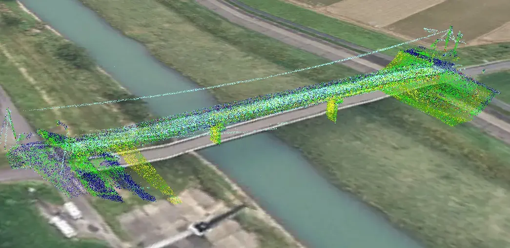
Large data processing
We will add the ability to convert point cloud displays (LAS data) to 3DTiles format and upload them. This will enable processing of larger data sets.
Enhanced search function
Testimonial
From the initial stages of the project, the development was carried out speedily. Due to the limited development period for this development, we were unable to determine detailed specifications. In this situation, agile development was used to prioritize the necessary functions, conduct technical research, and then build the necessary infrastructure and develop the front end. The accumulation of these efforts resulted in the completion of the project as a whole.
We were able to achieve these developments because we were able to check the progress of development and mutually confirm our requests through sprint reviews. We were supported by the "proposal ability" to show concrete results in response to detailed requests, and by the "technical capabilities" and "management system" that served as the background for the proposal.